
Unlocking Precision: The Power of Terrestrial Scanners, Photogrammetry, and LiDAR
In the ever-changing world of architecture, engineering, and construction, accurate and reliable land surveying is not only important but essential. As projects grow in complexity and technology evolves, modern land surveyors have an abundance of tools at their disposal to ensure precision and efficiency. Some of the most useful of those tools include terrestrial scanners, 2D and 3D photogrammetry, and LIDAR scanners, each transforming the way surveyors capture, analyze, and deliver crucial site data.
Terrestrial Scanner
| Terrestrial Scanner: A tripod-mounted fixed-position scanner used on surveys that demand a high degree of accuracy. |
Take the pavement monitoring of an active roadway, for example. A terrestrial scanner is a game changer, allowing the land surveyor to accurately and, more importantly, safely collect the information needed to analyze the road surface during active construction precisely. This scanner sits on a tripod and gathers explicit data from a fixed position. Once the scan is completed, the tripod can be relocated to multiple setups to collect all data from the site. While scanning, the equipment begins stitching together data points to create a 3D point cloud, allowing the surveyor to identify collected data points and where data is missing. This enables the surveyor to rescan as necessary before leaving the site.
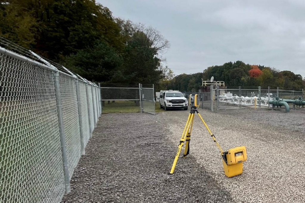
A terrestrial scanner setup in a fixed position.
Experienced land surveyors recognize the care needed to ensure the terrestrial scanner is set up accurately. Although an incredibly efficient tool in the field, if the scanner is not calibrated on a regular basis, the data collected will misinform office surveyors, resulting in inadequate or inaccurate deliverables.
Photogrammetry
| Photogrammetry: Aerial photographs from drones or planes with ground control points to create a 2D or 3D surface area. |
For ALTA/NSPS Land Title Surveys or topographical surveys, land surveyors may use photogrammetry to gather information via aircraft, be it planes or drones. During a flight, images are gathered and stitched together afterward with specialized software to begin the mapping process. Control points from the site are then used to correlate image information to exact known points on the ground. Depending on the data needed, this can produce 2D or 3D representations of a site’s terrain.
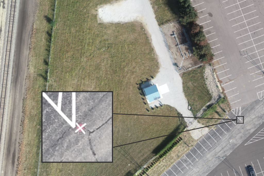
The use of placing control points on a site prior to sending a drone to capture site imagery.
Why use photogrammetry? It can be used to gather a massive amount of information, both quickly and safely, without having to put staff throughout the site to gather information ‘conventionally’. It can also be used as a checkpoint of thoroughness in collecting field data or to show project progress throughout various stages of construction. Whether the site is flown before field surveyors are on-site, as a preliminary review of existing conditions, or after fieldwork has been completed to confirm adequate information was gathered, photogrammetry is an excellent quality assurance tool with field crews.
This tool doesn’t come without limitations. Flying these drones or planes requires specialized training and certifications so that the surveyor can be confident in gathering the data accurately. Additionally, many external factors affect the flight. Things like extreme cold, tree foliage, shadows from the sun, and site locations near restricted flying areas, such as airports, all interfere with the ability to utilize photogrammetry. This means that careful planning is required to ensure both the accuracy of the data and the efficiency of the collection methods.
LiDAR Scanning
| LiDAR Scanning: Laser pulses are sent from the scanner to the surface or object, which collects thousands of data points to produce point clouds. |
LiDAR scanners gather precise data from large sites to aid project designs. There are two types: Aerial LiDAR Scanners (ALS), which measure from the scanner attached to a drone or fixed-wing/helicopter for survey sites such as wind farms, and Mobile LiDAR Scanners (MLS), which are mounted on moving vehicles to quickly scan areas unsafe for field work, such as roads and highways.
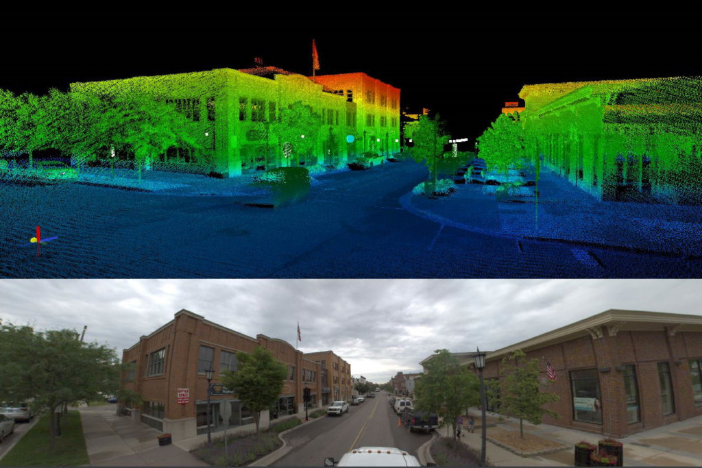
A Mobile LiDAR Scanner (MLS) collects data and creates point clouds along a busy street for roadway mapping activities.
Why use LiDAR scanners? LiDAR scanners are an efficient way to quickly gather highly accurate details of large areas. They provide the surveyor with a detailed point cloud that office staff use to create a comprehensive surface model. Plus, contrary to photogrammetry, LiDAR’s laser pulses can penetrate foliage and bounce off uneven surfaces, efficiently gathering a site’s data despite heavy vegetation and rough terrain.
While LiDAR provides many advantages, don’t forget its limitations. Similar to photogrammetry, LiDAR is temperature and weather-dependent, meaning the laser pulse has difficulty penetrating fog and snow, and cannot be flown in the rain. Additionally, the large amounts of data require specifically trained staff to take this data to create the required product, which can result in expensive processing costs pairing with costly equipment.
Land Survey Equipment Summary
In summary, terrestrial scanners, photogrammetry, and LiDAR technology are all excellent tools to amplify a land surveyor’s work on a project. When used appropriately, these technologies can boost your project. View the Technology Summary table below to review each technology’s best use, benefits, and limitations.
| Technology | Best Use | Benefits | Limitations |
| Terrestrial Scanner | Valve station expansion, electrical substation as-builts, road pavement monitoring | Extreme accuracy Assess the quality of data while scanning Safe method of collection for surveyor | Moving the scanner can alter accuracy Slower and more laborious to collect the data |
| 2D or 3D Photogrammetry | ALTA/NSPS Land Title Surveys and large topographical surveys | Cost-effectiveness High efficiency Real-time site conditions | Seasonal interference Sensitive to shadows Limited information regarding vegetation and extreme terrain Drone battery life |
| LiDAR Scanning | Wind farms, solar farms, and large-scale sites | Covers large areas quickly Ideal for inaccessible or unsafe terrain Penetrates heavy vegetation Easy to obtain additional data as needed | Seasonal interference Sensitive to shadows Drone battery life Costly equipment |
Whether it’s constructing a residential subdivision, establishing the right of way for utility mapping for utility improvements, developing a renewable energy site, or designing municipal roads, land surveying is an integral part of every project. Having a survey team that understands how to take advantage of this technology not only elevates project deliverables but also increases confidence in data accuracy and can improve project efficiency.
Precision, technology, and experience deliver more.
Originally founded as a land surveying company over 15 years ago, Metro Consulting Associates (MCA) continues to innovate, grow, and expand its survey capabilities to remain adaptive, nimble, and high-value. With MCA you get 500+ years of team expertise to help you achieve the impossible on your next project.
Learn more about our survey capabilities and contact our team to help you tackle your next project.

About The Author
Brad E. G. Oliver, PS


Stay connected!
Subscribe to News + Ideas